Riverside Walk launches new map and leaflet ahead of popular charity trek


This article contains affiliate links. We may earn a small commission on items purchased through this article, but that does not affect our editorial judgement.
The map of the Riverside Walk includes further information on the sights and history of some of the places on the 13-mile circular route, which encircles the town.
A new feature on the leaflet shows the location of walking surfaces which can be suitable for cycling and wheelchairs and those which could be muddy.
Advertisement
Hide AdAdvertisement
Hide AdTo help encourage full use of the pathway, the organisers have provided six interpretation boards showing the route and explaining some of the features to be seen near that point.
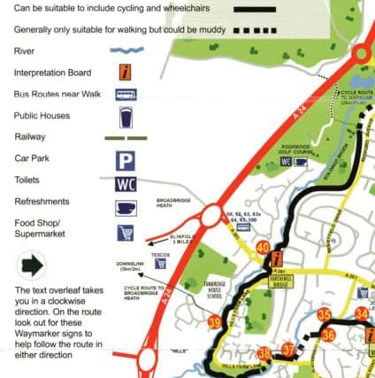
Seats have been installed at various locations, some with a hard surface alongside suitable for a wheelchair or buggy.
A grant from the County Local Committee provided the majority of the funding for the map and two more interpretation boards on the route.
Maps can be picked up at Horsham Museum, local libraries and other public places. It can also be seen on the Horsham Town Community Partnership (HTCP) website.
Advertisement
Hide AdAdvertisement
Hide AdJane Apostolou, chair of organisers, said: “We are very pleased to produce this map in time for spring weather and more walkers enjoying the path.”
The third annual Riverside Walk takes place this year on Saturday July 16.
The route leaves from the rugby club in Hammerpond Road at 10am and will be taken anti-clockwise this year. There is no entry fee.
Leaving the Rugby Club in Hammerpond Road at 10am, walkers pass through woodland beside the Horn Brook and will reach the first refreshment stop, the popular New House Farm café, four miles later.
Advertisement
Hide AdAdvertisement
Hide AdThe whole route doesn’t have to be completed in one day as it can be joined or left at a number of points along its length, to suit individual abilities.
On the day, a free minibus will be on hand to return walkers from several points to the start if they need to finish early.
The new map, combined with good signage, the short distances between refreshment stops and the easy walking terrain meets an aim of HTCP - making the walk more accessible.
Support for the event has been provided by the three Horsham Neighbourhood Councils, Denne, Forest and Trafalgar together with North Horsham Parish Council.
Advertisement
Hide AdAdvertisement
Hide AdThis year, the walk is helping to raise awareness of dementia and supporting the Alzheimer’s Society. Everyone taking part is encouraged to raise money for that charity by sponsorship.
Forms and other details can be obtained from the Alzheimer’s Society by contacting their fundraiser, Hannah Miller, by phone (01403 213012) or email [email protected]
Sponsorship of taking part in the event is not compulsory, but anyone wishing to raise money for the Alzheimer’s Society or any other cause is welcome do so.
Don’t miss out on all the latest breaking news where you live.
Advertisement
Hide AdAdvertisement
Hide AdHere are four ways you can be sure you’ll be among the first to know what’s going on.
1 Make our website your homepage at www.wscountytimes.co.uk
2 Like our Facebook page at www.facebook.com/wscountytimes
3 Follow us on Twitter @wscountytimes
4 Register with us by clicking on ‘sign in’ (top right corner). You can then receive our daily newsletter AND add your point of view to stories that you read here.
And do share with your family and friends – so they don’t miss out!
The County Times – always the first with your local news.
Be part of it.