Has Google Earth image revealed Roman villa at controversial housing site?


Fontwell resident Jon Cann, of Arundel Road, spotted what he believes could be the outline of the ancient structure after a chance glance of aerial photography.
Mr Cann and fellow residents, who have for years campaigned against the planned 400-home Dandara development, have called for an extensive archaeological survey to determine whether their claim is accurate.
Mr Cann said: “It was just pure chance and pure curiosity.
Advertisement
Hide AdAdvertisement
Hide Ad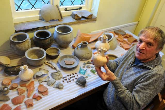
“I could see a few lines and I saw what appeared to be bathing rooms. I have measured them and they are in scale.
“Of course the jury’s out until we get a proper evaluation of it.”
Rumours of an undiscovered villa have been circulating around the village for years.
In the late 1990s, Mr Cann unearthed a staggering 8,000 first and second century artefacts in his garden, when he was digging a soakaway for a house extension.
Advertisement
Hide AdAdvertisement
Hide AdIt was believed to be a boundary ditch, filled with domestic rubbish.
Items included pottery, glass, roof tiles and ironwork.
The discovery was made around 40 metres from the boundary of the proposed development site.
Mr Cann plans to bring the aerial photographs to the attention of a planning inquiry in November.
The homes application was called in by the Government over concerns it was contrary to the parish neighbourhood plan.
Advertisement
Hide AdAdvertisement
Hide AdA spokesman for Arun District Council said the photographs may be ‘agricultural’ in nature but had asked the developer to carry out additional surveys.
They said: “The council understands local residents’ concerns.
“Arun has sought the views of its archaeological advisor who said it is likely that the features that appear in crop marks are agricultural rather than evidence of buildings.
“However, the council is going to invite the developer to carry out some additional trial trenching in the area in question so that the planning inspector at the forthcoming public inquiry will be fully informed on the issue.”
Advertisement
Hide AdAdvertisement
Hide AdRachel Allwood, planning director at Dandara, said she did not think the aerial photo represented ‘compelling evidence’.
She said: “We have had a full independent archaeological investigation undertaken by the Centre for Applied Archaeology at the Institute of Archaeology University College London, agreed and assessed by both West Sussex County Council and Arun District Council.
“This included extensive trenching which resulted in no evidence to suggest the site is of special archaeological value.
“Had the investigation revealed anything of interest we have been required to trench the whole field. Against this background of expert investigation at the site, we do not think that a Google Earth photo presents any compelling evidence.”
Historic England has asked campaigners to share their findings with them ahead of the public inquiry.